Saturday July 30, 2011: Starting Mileage=127.8, Ending Mileage=136.1. Starting Elevation Gain=25,050', Ending=27,650'. Goddard Canyon Junction To Evolution Meadow To Evolution Lake, 8.3 Miles, +2600'.
Woke up to a very damp scene. Tried to dry things out and didn't get moving until 9:00 am. A ridiculously late start, but I did not want to pack everything up wet. The clouds were already building by the time I got going, it was going to be another stormy day. My original plan was to hike up to Sapphire Lake, but that did not happen. Made it to the worst crossing of the whole trip, Evolution Creek, at 10:30 am. It was a wide crossing, about 100 yards across and deep. It ran just above my waist. I put on the crocs and in I went. It was a very strong current, probably due to rain run off, definitely the worst crossing of the whole trip. I made it across safely, dried off, well, sorta, and kept on moving. Made it to the McClure Ranger Station at 11:15 and chatted with the ranger. He told me about the Whitney Portal mess. He said we would be wise to hunker down at the first sign of bad weather. He then took my name and itinerary. The Rangers were instructed to take down hikers names and where they were planning on going to keep track of us through this bad weather. Wasn't very comforting. Just as I was leaving the ranger station I heard the booming sounds of thunder and saw a lightning bolt (not in that order of course). Aaron, Paul and myself decided to make camp before it got worse. We found a nice clearing in the forest looking out to the meadow and creek then set up. I was in my tent at 11:45 after only hiking 4.3 miles. Pretty bummed out, this was going to put me behind schedule and with even worse weather forecast tomorrow, possibly way behind schedule. Another bummer was the storm was blocking what normally is a grand vista of twelve and thirteen thousand foot peaks. It started to rain pretty consistently, but at least I set up while it was dry. Did some journaling, had some lunch and tried to rest. About an hour and a half went by when sunlight came in through my tent. I got out and had a look around. It had stopped raining and there was some blue sky to be seen (still alot of clouds). The three of us decided to move up to Evolution Lake four miles away. I packed up and was back on the trail at 2:00 pm.
It stayed nice for about an hour then started up again. At first just a light rain, then by 3:30 pm it was lightning, thunder and rain. No hail this time. I was about half a mile out when the rains became heavier. I made good time in the rain, its like natures whip on a horses rear end, nothing like a lightning strike to get you moving. By the time I made it to Evolution Lake it was pouring, so I made another makeshift camp. This one was a little better than yesterdays, but by no means ideal. I was able to pitch the tent without the inside getting too wet, I must be getting used to this :o So it was now 5:00 pm and I was hunkered down in my tent listening to rain and thunder outside my nylon fortress. Its amazing how much peace of mind that thin peace of nylon provides. My mental state was being tested by this whole ordeal with the T-Storms. I am so grateful for the support I have from my wife. She was great throughout the planning stages, having her bring me to Yosemite to start the trip off was great and knowing I had her to go home too after this ordeal gave me the strength to actual smile in these situations. She sent a picture of us to me in my bucket from a cruise we took and that would make me smile every time.
The rains let up around 7:00 pm and I was able to come out of the tent and have a dry dinner. One thing these storms did was to keep the mosquitos down. I talked the day and the next days plan over with Aaron and Paul and we all agreed to wake up early and get over Muir Pass before the T-Storms got going the next day. I got to witness a spectacular sunset as the sun broke through the clouds as it sank in the horizon. As a photographer this was great. But I was missing out on seeing Mt. Darwin, Mt. Mendel and the rest of the Evolution Peaks. Definitely need to come back up here and spend some time, just a magical area. So, new plan is to get over Muir Pass and at least to the Le Conte Canyon trees before tomorrow's storm.
 |
| Very Wet & Cold Campsite |
 |
| The Hermit |
 |
| Clouds Building Over Mt. Darwin & Mt. Mendel |
 |
| Break In The Clouds |
 |
| Though It Can Be A Pain, Storms Reveal Great Beauty |
Sunday July 31st, 2011: Starting Mileage=136.1, Ending Mileage=149.6. Starting Elevation Gain=27,650', Ending=29,000'. Evolution Lake To Bishop Pass/Le Conte Ranger Station Junction, 13.5 Miles, +1350'.
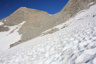
Didn't get up as early as I would have liked, but I was on the trail by 7:00 am. It was cold this morning with building clouds already. Muir Pass was today's main objective. My boots were still soaked from the previous two days, just had to deal with it at this point. The snowed started in earnest after Sapphire Lake (which is a beautiful location, would love to camp here someday). The long slog through the snow would go on for hours, three and a half miles on the north side of the pass and three miles on the south side of the pass. Muir Pass is very gradual on both sides as opposed to say Mather Pass which is steep on both sides. In dry conditions Muir Pass seems like it would be a breeze, but with miles and miles of snow, this would take some time and energy. The views on the other hand were enhanced by the clouds and abundant snow. If not racing mother nature, this would be a great place to explore and spend some time. The lakes on both sides of the pass were still frozen. It looked like February, not the middle of summer. There were great views of Mt. Goddard and the Goddard Divide. Yet another mountain I plan to climb someday. I arrived at the pass at 11:00 am. There is a stone hut built in honor of John Muir atop the pass. You take care shelter in the event of a storm here (a group had to take shelter here later in the day, this was a bad day to be up here). Didn't spend much time on the pass, had to get into treeline asap, the dark stormy clouds were here. It was roughly four miles to the forest cover, so I would be exposed, not good. The slip and slide down the snow was okay, but it was time consuming. At noon the rain began. I put on the rain gear and pack cover and pressed on. For three hours I would hike through moderate to heavy downpours, there were no breaks in the action, it was very steady rain. It did not feel like a summer thunderstorm, more like a system had moved in. Didn't get to see any of the normally grand views, the clouds were very low and hung just above me all day. I was able to stay dry and warm sans the boots, others did not fare as well. Today would be the last day for a number of hikers, they had enough. Cold, wet and unable to dry out along with the snow and river crossings was many peoples breaking point and I don't blame them. The trail turned into a stream and it was getting slick. Small rocks and sand were washing across the granite making for unpleasant walking conditions and my boots were squishing with every step. Oh and the stream crossings were all deeper and swifter because of the rain. One positive in all this, I did not have to stop to put on my water shoes for the crossings, I just walked through, boots couldn't get any wetter. Three hours of rain and walking was enough. I got to the LeConte Ranger Station/Bishop Pass junction and made camp. I was several miles short of todays goal, but no more hiking like this for me, it was time to wait this out. All of my gear held up nicely through the storms, everything did what it was supposed to, keep me and the pack dry. Before the trip I replaced my Mamot Precip jacket with the REI Kimtah jacket and I am glad I did. The Precip would not have held up to these conditions, this Kimtah held up very well.
I arrived at my camp at 3:00 pm and was joined by Aaron and Paul. We discussed the weather and all agreed staying here was best. The ranger was out on patrol and was due back in the late afternoon. I wanted to see if he had an updated weather forecast so camping here was advantageous. The rains were now light and I was able to make a sorta dry camp inside my tent, not as bad as the previous two days. Todays storm was not an electrifying event, just alot of rain. By 4:00 pm the rains had stopped. I wanted to make a fire to warm up and dry off. Luckily I had waterproof matches and tinder. Another hiker rolled in and he started the tinder while the rest of us hunted under rocks and logs for dry wood. We found enough and got a fire going. Many soggy hikers passed by and decided the fire looked enticing and camped with us. By the time night fell, we had twelve tents and fifteen people, the fire was attracking people big time. It was nice sharing stories with other hikers, everyone had some adventure it seemed. People getting swept away in creek crossings, people slipping off logs into creeks while crossing, people hunkering down in the Muir Hut to avoid the storm, people camping right on the trail because they had no other option in a storm, one guy fell face first into crossing and his packed pinned him down underwater, he was able to roll out of it though, another guy slid down a snow slope and stopped just before falling into a frozen lake. These stories sadly boosted my spirits, I thought I had it bad, I guess I was wrong.
I was able to talk to the LeConte Canyon Ranger later on. He was encouraging, he said to roll with the punches and adapt. He did not have an updated weather forecast, the hard winter knocked out his repeater and his radio died. He did think in his opinion the weather would start to clear tomorrow. Either way, I was thinking positive and moving forward. It ended up being a good camp by the fire. Everyone was grateful for the fire. As I layed down for bed, I had encouraging thoughts and was ready for the next day, August 1st was tomorrow and that made me happy, the sixth wasn't that far off.
 |
| Sapphire Lake |
 |
| Goddard Divide Behind Sapphire Lake |
 |
| Mt. Solomon & Mt. Goddard |
 |
| Frozen Wanda Lake |
 |
| July 31st |
 |
| The Never Ending Trek To Muir Pass Through The Snow |
 |
| Muir Pass & Hutt |
 |
| Helen Lake |
 |
| Time For The Rain Gear |
 |
| North Palisade Looming |
 |
| Was Able To Build A Fire Near The Le Conte Canyon Ranger Station. A Welcome Sight To Many |
Monday August 1st, 2011: Starting Mileage=149.6, Ending Mileage=161.3. Starting Elevation Gain=29,000', Ending=31,900'. Bishop Pass Junction To Upper Palisade Lake, 11.7 Miles, +2900'.
Woke up feeling good. A dry night of rest and my optimistic outlook did the trick. This would be the last time I would see most of these hikers too. Alot went out and over the Bishop Pass trail to the town of Bishop, they were done. Four other guys wanted to finish on Friday August 5th and were planning on a very long day to get over Mather Pass, 15 miles and +4000' away. I started off with the same plan but decided against it for two reasons that follow. I started hiking at 7:00 am. I was still rather soggy from the prior day. My camera lens wouldn't un fog, everything was damp. The first 3.3 miles were downhill, always a good way to start a day, get the blood flowing before climbing. I made it to a sunny spot on the trail and took an hour break to dry things out. Shoes, camera, socks, tent and clothing. I said farewell to Aaron and Paul as they raced ahead. It was great camping with them the past three nights but we had different exit dates and they needed to push today. I wanted to dry out. The long break in the sun felt good. I was also able to get some solar charging in to power my video camera and I-Pod. Next up was the famous golden staircase that would take me up to the Palisade Lakes. It is an ever switchbacking trail that climbs nearly 2000' in a couple of miles. The views west were impressive, the Devils Crags looked imposing to climb. As I climbed yet higher, my first view of the Palisades was upon me. Giant peaks, 14,000' +. I could see Middle Palisade, Norman Clyde and Disappointment Peak all ahead. So impressive. As I started heading south again at Lower Palisade Lake, the dark clouds started to churn up. I thought I was in the clear with this, but these storms had one more round in store it seemed. Mather Pass which was straight ahead was very dark and gloomy, I wished Aaron and Paul the best of luck with that. I arrived above the Upper Palisade Lake area and it started to rain again, albeit lightly. I decided I was making camp for the night, didn't want to get wet again, especially after drying out. The dark clouds remained for the afternoon, but it never did rain much. I was able to do more solar charging and drying out. The photography was good too. My spirits were lifting. I was a bit behind schedule though and would have to make some big mileage if I was to finish August 6th. These past four days were very draining, a nice sunny day is what I needed to get back on track. Even though the past four days were stormy ones, I was able to average 12.2 miles a day, so I wasn't that far behind. I later met Roberto from Sweden by way of Germany and we would camp together. He was due to finish August 6th as well. Though we didn't hike together much, we did camp at the same places for the rest of the trip. He would end up being a great camp neighbor to exchange stories with. I went to bed early in hopes of making big mileage the next day.
 |
| Clouds Have Lifted |
 |
| Canyon Down The Middle Fork Kings River |
 |
| Coming Up The Golden Staircase With The Devils Crags As A Backdrop |
 |
| Middle Palisade |
 |
| Mather Pass Under A Stormy Sky, Will Camp Here For The Night |
 |
| Staying Dry & Feeling Good |
Tuesday August 2nd, 2011: Starting Mileage=161.3, Ending Mileage=181.5. Starting Elevation Gain=31,900', Ending=35,500'. Upper Palisade Lake To Woods Creek Bridge Crossing, 20.2 Miles, +3600'.
Woke up on time and was on the trail at 6:00 am. The weather was looking steady so away I went. If all went well, I would climb over Mather Pass then attempt Pinchot Pass as well. But first things first, big bad Mather Pass. I was 1300' and one and a half miles away. The snow on the north side was solid ice and I could not make out any boot track. Looks like the rains had smoothed/melted out the snow and overnight it became ice. I was on it before the snow had a chance to soften it. I had to be very cautious with my foot placement. Many times I had to stomp down a track to ensure a good traction. This took forever to climb. I didn't get to the top of Mather until 7:45 am. Almost two hours to climb a mile and a half. That was alot of work and fairly stressful. I would later find out that my new boot path made it easier for the parties that followed later that day. The views from atop the pass were great. It was clear and I could see for miles. The Palisades to the north, Upper Basin to the south. Split Mountain off to the east and so many peaks south of me, stunning. Stories I heard earlier in the trip made the south side of Mather sound difficult, something about an ice cave??? Well, there were no ice caves or other problems to mention, it was smooth sailing down to the beautiful Upper Basin. This area is new to me and I was impressed. I really enjoyed this section of trail. The hike down Upper Basin is nice, gradual and on sandy, but solid ground. You can really move here. There were a couple of crossings along the way, but nothing of trouble. I descended all the way to the South Fork of the Kings River in what seemed like no time at all. And the best part, it was nice and sunny. I needed to get wet to cross this waterway, so I took a nice long siesta on the other side while drying off. From here it was a 2000' climb up to Pinchot Pass. The nice thing was the views got grander and grander on the way back up to the pass. I could see the entire Upper Basin all the way to Mather Pass. Mt. Ruskin looked impressive towering over the South Fork Kings River. The lakes going up to Pinchot were beautiful and blue. Particularly stunning was the view looking back down at Lake Marjorie, I would like to camp here someday as well, breathtaking. The mountains adjacent to the pass were dark red, they looked so different than the rest. There was very little snow on the north of Pinchot Pass so I got up it quickly. Towards the top I got to see my favorite Sierra Wildflower, the Polemonium, aka Sky Pilot. It has a lovely fragrance and the purple flower is so pretty. They mostly live in the southern half of the Sierra's at very high elevations, a real high altitude survivor.
The views from the top of Pinchot Pass were stunning as well. This is the scenery I had been dreaming of. So many peaks in all directions, hundreds of lakes and waterways. Just a magical place, was really in awe. The mountains to the south were impressive looking, but looking north I could see the huge Palisade Peaks above Mather Pass, someday, someday. I now had 7.6 miles to reach Woods Creek camping area. I was making great time so I hiked down off the pass, found a meadow and took another siesta. I was very much at peace here. Just relaxing and enjoying the great weather and scenery, this was great, I wish I could spend an entire day relaxing here. The first three and a half miles was a gentle descent through meadows and rock bands. Great to walk down and very scenic. I could see where I was eventually headed too. Mt. Clarence King stood out to the south west and I knew I had to go that way. Everything changed once I reached the Sawmill Pass junction. One, I ran out of food for the day and was getting hungry and two, the trail was now going steeply downhill. Giant granite steps and dry brush replaced the meadows and sandy trail. This section of trail follows the very violent Woods Creek and avalanche debris was all over the trail. Looks like it happens often in the winter. There were huge rocks and trees ripped apart all over this section of trail. Snow had consolidated so much from avalanche compression that alot of it remained right in Woods Creek. The creek was blasting a tunnel through the ice and snow, must have been a very large avalanche this winter. Down and down i went, all the way to 8,492'. I had to cross the White Fork of Woods Creek. It was a fast moving wet crossing, just what I needed at the end of the day :(. I finally arrived at the campground at 5:00 pm. Twenty miles and two passes today, I made up alot of time but I was still behind schedule, but another good sunshine day would fix that problem.
To my dismay, there was a rather large troop of Boy Scouts camped here, but I would deal with it. They have a tendency to be loud with the wrong troop leaders. Scouts seem to be either well behaved or the exact opposite, this one was okay behaved :). At 6:15 pm, Roberto rolled into camp. He had made the twenty miles too. It was nice to chat about the passes and the day that was. Today was a great day on the John Muir Trail. I am getting close to the finish and the weather is looking great. Very happy. I would sleep great tonight.
 |
| Early Morning Light |
 |
| Looking Back To Upper Palisade Lake, Middle Palisade To The Right |
 |
| One Of The Sierra's 14ers, Middle Palisade, Elev 14,040' |
 |
| Mather Pass From The South |
 |
| One Of My Favorite Areas On The JMT: Upper Basin |
 |
| Upper Basin |
 |
| Mt. Ruskin |
 |
| Beautiful Scenery Looking North On Climb To Pinchot Pass |
 |
| Lake Marjorie |
 |
| Looking To Mather Pass From Pinchot Pass |


No comments:
Post a Comment