I took daily videos while on the trail and finally uploaded them to the net. They are all un-edited and raw footage from my journey. All the emotion from the trail is here to see.....
http://calicokat.smugmug.com/Hiking/Sierra-Nevada/John-Muir-Trail-2011-Videos/19882581_7LgVvJ#1565992970_25Z6R2N
Friday, November 4, 2011
Monday, August 22, 2011
Pre-Trip In Yosemite, Days 1-4 On The JMT Trip Report & Photos
Pre-Trip In Yosemite National Park
Tuesday July 19th, 2011: Left The House About 7:30 for our trip to Tuolomne Meadows Campground. Myself, My Wife, My Niece and our two Dogs were off. After a beautiful and scenic cruise up US 395 we arrived at the Tioga Pass park entrance around 2:45. After purchasing our annual park pass ($80.00), we headed west for the campground. Initial reaction was, "there is alot of snow on the mountains and passes, glad I brought the Ice Axe." After getting the whole bear scare from the rangers, we made it to our camp at 4:00. Didn't take us long to set-up and relax.
Got a nice campfire started and chillaxed with a glass of wine, good times. It felt good to relax. All the preparation and last minute running around was taking its toll on my sanity, so these next few days with the family were needed to get my head straight. It didn't hurt being in Yosemite, what a beautiful and stunning place. We had a steak, potatoes and corn on the cob dinner that was terrific, then hit the sack. Good day.
Wednesday July 20th, 2011: Got up rather late in the camping world, 8:00 am. But it was a good restful night of sleep. Started off with some coffee and pancakes, m & m pancakes that is :). After the wonderful breakfast, my niece and I set out for North Dome. We drove to the Porcupine trailhead and started hiking around 10:00 am. It is one of those backwards hikes, starts higher and goes down, down, down to North Dome. Pretty little hike I must say. The views looking across to Half Dome and the valley floor were spectacular, what a sight. The hike back up to Tioga Road required some huffing and puffing, but nothing for a sixteen year old cross country athlete. Drove back to the campground, dropped off Jackie and picked up Judy. But first we all had a chicken/cranberry salad sandwich for lunch, so tasty.
Judy and I headed back out for Lempert Dome. Judy has been nursing a badly sprained ankle from March and this was her first real hike since and she did great. Lempert Dome was just what we needed, short but sweet. A really beautiful view from the summit. A great day on the domes of Yosemite. When we arrived back at camp, Jackie had a nice campfire going and had already started dinner. What a day :) We had another round of steak, potatoes and corn, drank some more wine (and Whisky) and called it a day, I mean a great day.
Thursday July 21st, 2011: After another great night of rest we were up and at em much earlier today, 7:00 am. It was cold, needed to bundle up to make coffee and breakfast. More of the same, M & M pancakes :). The mission today was to move to much lower ground. We packed up our site and left Tuolomne Meadows Camp for Upper Pine Camp all the way down in Yosemite Valley. But first I had to take care of two things. First off was dropping my food re-supply for days three through eight in the Dog Lake Trailhead bear boxes. I did not want to carry all that extra weight up from the valley floor and this was a great logistical spot to leave a food drop. I had talked to the rangers prior to this and although they weren't jumping for joy in approval, they didn't disapprove the drop as long as I put my name and pick up date on the box. The second thing to do before leaving Tuolomne was to get an ice cream at the general store, mission complete. The drive down to the valley floor was gorgeous, it is simply a stunning drive, one I will never tire of. Up next was the majestic Yosemite Falls. Normally it dries up by August, but not this year, it was roaring full speed. So much beauty, so much water. We had a picnic lunch next to the Merced River with a great view of the falls. can't beat that. Next it was time to pick up the wilderness permit. We parked at the general store parking lot and walked the dogs along the bike/walk path. Getting my permit was fun. The ranger told me in not so many words that my itinerary was too aggressive for the conditions and changed my exit date from the sixth to the tenth. I know he was being helpful, but I did not have enough food to go that long, trying to put a scare into me :o. Upon arriving back at the truck, we discovered a pastry had been left out in the back of the truck and something (more than likely a bear) had made a mess of it before being scared off.
From the valley store we drove over to Upper Pines Campground. We saw news vans driving around but did not know at the time what they were looking for. Sadly we now know. Three people went over the edge of Vernal Falls to their death the previous day, truly sad. The Upper Pines Camp had a very different feel to it than Tuolomne Meadows. They were both listed as full and sold out, but we never felt crowded up at Tuolomne. Upper Pines was a zoo in comparison. Tents, trailers, cars and people everywhere. Our neighbors were noisy and sloppy. Food left out, draining water from tuna cans right on the ground next to their tents, trash on the ground. No wonder the Yosemite Bears like it here. We set up our camp then drove over to "Housekeeping" for a nice hot shower, it was a wonderous thing to get a hot shower before my trip. Back at camp Judy and Jackie prepared a delicious meal; whole wheat pasta, marinara sauce and turkey sausage while I put together my pack for the next morning. It was perfect before a big trip. After dinner we walked over to the Happy Isles Trailhead where I would be departing the next morning. We found that walking there from camp was much easier than trying to drive. I was starting to get nervous and sad. I had a great three days with Judy, Jackie, Honu and Hana and I did not want it to end.......
The John Muir Trail
Friday July 22nd, 2011: Happy Isles To Sunrise Trail Camp, 18.0 Miles, +7500'.
Had a so so night of rest in camp the prior night. Nervous and anxious mostly. Oh, and the campground was a tad noisy. I woke up at 5:30 am and started packing things up. Had some coffee and a pastry while Judy and Jackie got up. They walked me to the trailhead where Jackie said her goodbyes, then Judy walked me up to the John Muir Trail mileage sign. It was hard to say goodbye. We had never been apart this long and it was already wearing heavy on my emotions. We had an emotional departure and I was off for sixteen days at 0700.
Had a so so night of rest in camp the prior night. Nervous and anxious mostly. Oh, and the campground was a tad noisy. I woke up at 5:30 am and started packing things up. Had some coffee and a pastry while Judy and Jackie got up. They walked me to the trailhead where Jackie said her goodbyes, then Judy walked me up to the John Muir Trail mileage sign. It was hard to say goodbye. We had never been apart this long and it was already wearing heavy on my emotions. We had an emotional departure and I was off for sixteen days at 0700.
I hiked up the John Muir Trail proper to the top of Nevada Falls in no time. It was a beautiful day and I enjoyed hiking to the top of the falls. So far, so good, but I had a long way to go today. After crossing the bridge, I ran into lots of people. This was the Half Dome dayhike crowd. I did not fit in with a full overnight pack amongst the dayhikers. I pushed on up and up to the Half Dome junction. I was able to drop my pack off to the side of the trail and hike the remainder of the way to the top with just my camera, some water and food. It felt good. I made good time to the area where the rangers checked permits. They are really strict about the permits this year. They were taking down names coming and going. After that the views really opened up as I approached the sub dome. This was my first time on Half Dome and I was in awe. Just a spectacular view, I was really enjoying this. I had heard all the horror stories about the cables but the permit system must be doing something because I was able to climb up fairly freely. Luckily I was able to pick out a rather decent pair of gloves from the pile at the base of the cables to protect my hands (mainly for the descent). I was able to take some nice video's and photos on the way up. The weather was perfect for an ascent of Half Dome, not a cloud in the sky. Made it to the top and enjoyed the views in all directions, the Valley Floor, over to Glacier Point, up Tenaya Canyon, across to North Dome. Doesn't get much better than this. Only thing I would change is to have Judy up there with me. The climb down the cables was fun in my opinion, I really did a number on the gloves though, quite a bit more friction going down. Made it back to my heavy pack in no time.
After putting on the heavy pack I wandered on down the trail to the Clouds Rest Junction where I took a nice long break beside the creek. Soaked my feet, had some lunch and took a little nap. Again, the weather was perfect. From the Half Dome Junction all the way to Tuolomne Meadows I saw just a few people, a fry cry from the valley floor crowd. After my afternoon siesta it was off to look for a camp. I had originally planned to camp alongside Sunrise Creek in the 8500' region, but once I got there it felt dark and gloomy. I was already rather tired climbing out of the valley but made the decision to push to Sunrise Trail Camp. I wasn't all that jazzed about climbing to nearly 9900' before dropping to Sunrise at 9300'. Whew, what a day. I ended up hiking for ten hours, going 18.0 miles and going up 7500' of elevation gain. I was tired and really missing my wife. I set up camp, had some Mountain House Rice & Chicken with a flour tortilla and olive oil. It hit the spot even though my appetite was suddenly suppressed. Its like your body starts to work against you, I needed all the calories I could get, but my appetite was waning. The magnitude of the trip was starting to really set in. This was only night one of fifteen. How was I going to do this? How was I going to find the strength mentally and physically each and every day? I did my Journaling, watched some Lilo & Stitch on my I-Pod and hit the sack. What a first day.
 |
| Myself At The Start, Only 211 Miles :o |
 |
| Nevada Falls |
 |
| Half Dome Cables |
 |
| My First Summit Of Half Dome, Good Way To Start The JMT |
 |
| Descending The Cables, Quite Steep |
 |
| Tenaya Canyon |
Days 5-8 Trip Report & Photos
Tuesday July 26th, 2011: Starting Mileage=66.5, Ending Mileage=82.8. Starting Elevation Gain=14,000, Ending=17,850'. Reds Meadow To Lake Virginia, 16.3 Miles, +3,850'.
Woke up at 0530 feeling pretty good. I slept good considering how noisy it was. I was getting slightly ahead of schedule and decided to push on to Lake Virginia and bypass Purple Lake where I originally planned to camp. The forest leaving Reds Meadow was burned down by the Rainbow Fire in 1992. Very interesting to see what plants are making a comeback nearly twenty years later. As I climbed higher towards Red Cones it became quite cold, cold enough to wear the old balaclava. Made it to Deer Creek in good time. My guidebook (John Muir Trail by Elizabeth Wenk) said to fill up on water here as the next five miles were dry. I am glad I had that advice because the next stretch was indeed dry, steep and went on forever. Made it to the Duck Lake drainage and had to get wet to cross. It was actually a nice rinse off/cool down from the hot/dry section I just traversed. Throughout the trip I tried to plan my lunch around a stream crossing, that way I could dry off and relax. Some days (like today) that worked, other days it did not. After lunch I had to roller coaster my way up to Purple Lake, which was beautiful, then up again to Lake Virginia.
Awww, Lake Virginia. Up until this point, this was the most scenic campsite. Arrived about 3:00 pm, in time to take a swim, do some laundry, eat some more lunch and relax. The lake is magical, so pretty. It is nestled between striking mountains and there were great views to the Silver Divide to the south. I would not be camping alone tonight. As the hours passed by, alot of the people from Reds Meadow started to trickle in. Seems that was the plan for the day for at least eight people. I was calling it the Reds Meadow after party. That was okay as this group was quiet and focused on backpacking more than it being a social event. The plan for tomorrow was originally to go to Pocket Meadow, but it wasn't that much farther to Vermillion Valley Resort. There I could call Judy (which would be a surprise), get a hot meal, hot shower and do some laundry. I would have to do bigger mileage, but it was sounding like a great idea. Tomorrow would be Silver Pass, there would also be a couple of bigger stream crossings tomorrow. Mono Creek awaits......
 |
| Looking Back At The Yosemite High Country |
 |
| Purple Lake |
 |
| Sunset View From Lake Virginia |
Days 9-12 Trip Reports & Photos
Saturday July 30, 2011: Starting Mileage=127.8, Ending Mileage=136.1. Starting Elevation Gain=25,050', Ending=27,650'. Goddard Canyon Junction To Evolution Meadow To Evolution Lake, 8.3 Miles, +2600'.
Woke up to a very damp scene. Tried to dry things out and didn't get moving until 9:00 am. A ridiculously late start, but I did not want to pack everything up wet. The clouds were already building by the time I got going, it was going to be another stormy day. My original plan was to hike up to Sapphire Lake, but that did not happen. Made it to the worst crossing of the whole trip, Evolution Creek, at 10:30 am. It was a wide crossing, about 100 yards across and deep. It ran just above my waist. I put on the crocs and in I went. It was a very strong current, probably due to rain run off, definitely the worst crossing of the whole trip. I made it across safely, dried off, well, sorta, and kept on moving. Made it to the McClure Ranger Station at 11:15 and chatted with the ranger. He told me about the Whitney Portal mess. He said we would be wise to hunker down at the first sign of bad weather. He then took my name and itinerary. The Rangers were instructed to take down hikers names and where they were planning on going to keep track of us through this bad weather. Wasn't very comforting. Just as I was leaving the ranger station I heard the booming sounds of thunder and saw a lightning bolt (not in that order of course). Aaron, Paul and myself decided to make camp before it got worse. We found a nice clearing in the forest looking out to the meadow and creek then set up. I was in my tent at 11:45 after only hiking 4.3 miles. Pretty bummed out, this was going to put me behind schedule and with even worse weather forecast tomorrow, possibly way behind schedule. Another bummer was the storm was blocking what normally is a grand vista of twelve and thirteen thousand foot peaks. It started to rain pretty consistently, but at least I set up while it was dry. Did some journaling, had some lunch and tried to rest. About an hour and a half went by when sunlight came in through my tent. I got out and had a look around. It had stopped raining and there was some blue sky to be seen (still alot of clouds). The three of us decided to move up to Evolution Lake four miles away. I packed up and was back on the trail at 2:00 pm.
It stayed nice for about an hour then started up again. At first just a light rain, then by 3:30 pm it was lightning, thunder and rain. No hail this time. I was about half a mile out when the rains became heavier. I made good time in the rain, its like natures whip on a horses rear end, nothing like a lightning strike to get you moving. By the time I made it to Evolution Lake it was pouring, so I made another makeshift camp. This one was a little better than yesterdays, but by no means ideal. I was able to pitch the tent without the inside getting too wet, I must be getting used to this :o So it was now 5:00 pm and I was hunkered down in my tent listening to rain and thunder outside my nylon fortress. Its amazing how much peace of mind that thin peace of nylon provides. My mental state was being tested by this whole ordeal with the T-Storms. I am so grateful for the support I have from my wife. She was great throughout the planning stages, having her bring me to Yosemite to start the trip off was great and knowing I had her to go home too after this ordeal gave me the strength to actual smile in these situations. She sent a picture of us to me in my bucket from a cruise we took and that would make me smile every time.
The rains let up around 7:00 pm and I was able to come out of the tent and have a dry dinner. One thing these storms did was to keep the mosquitos down. I talked the day and the next days plan over with Aaron and Paul and we all agreed to wake up early and get over Muir Pass before the T-Storms got going the next day. I got to witness a spectacular sunset as the sun broke through the clouds as it sank in the horizon. As a photographer this was great. But I was missing out on seeing Mt. Darwin, Mt. Mendel and the rest of the Evolution Peaks. Definitely need to come back up here and spend some time, just a magical area. So, new plan is to get over Muir Pass and at least to the Le Conte Canyon trees before tomorrow's storm.


 |
| Very Wet & Cold Campsite |
 |
| The Hermit |
 |
| Clouds Building Over Mt. Darwin & Mt. Mendel |
 |
| Break In The Clouds |
 |
| Though It Can Be A Pain, Storms Reveal Great Beauty |


Days 13-16 & Post Trip Report & Photos
Wednesday August 3rd, 2011: Starting Mileage=181.5, Ending Mileage=198.0. Starting Elevation Gain=35,500', Ending=40,000'. Woods Creek Junction To Center Basin Camp, 16.5 Miles, +4500'.
Was on the trail at 7:00 am today. Had a good night of rest, but was feeling sluggish and hungry this morning. The twenty miles yesterday took alot of energy, I would have to adjust food rations to keep up, problem was I had the exact amount of food to get me to the finish Saturday. If I ate more today, I would have less later on. I resorted to rationing, instead of eating a bar for morning snack, I would have to eat half now and the other half later. Today was going to be another tough one as I had to climb out of Woods Creek past the Rae Lakes and on up to Glen Pass 3500' higher. Then it would be a downhill climb to Vidette Meadows and another 1000' climb to Center Basin. So 4500' of climbing in 16.5 miles. Not a good day to feel sluggish and hungry this early on, but there would be a blessing later. Back to climbing. The trail from Woods Creek to Dollar Lake was slow and monotonous, just a steady uphill through forested terrain. Once at Dollar Lake the views really open up. Fin Dome, Painted Lady, Mt. Clarence King to the south, Diamond Peak to the east and Pyramid Peak to the north. Great views. I was starting to feel better as I ate more and the weather was perfect again, such a drastic change from a few days ago. I was really worried about food now so I checked the bear boxes I came across at the upcoming lakes, but it seems the ranger had recently done a sweep as all the boxes were empty and left open. From past experiences, there is usually some goody that a backpacker left behind in the boxes, but not this time. The mosquitos in the Rae Lakes area are known for being bad in a normal year so I lathered up in good old deet before reaching them. I am glad I did, there were clouds of them here. They would hover all around me but not land on me, the deet really does work.
The climb from the Rae Lakes to Glen Pass was enjoyable. Great scenery that gets better and better the higher you go. There was a decent amount of snow coverage from 10,500' on up to the 11,978' pass, but nothing too bad. There was a nice boot track and being 10:00 am the snow was in great shape, not icy and not slushy. Most of the lakes and tarns were frozen here as well. It was some winter up here, it is August and the passes have alot of snow and the lakes are frozen. I got to the top of the pass around 11:00 pm and I was tired. My food rationing was not giving me enough energy. I had to climb with my rhythm steps. Take one hundred steps, take five deep breaths and repeat, this works very well for me climbing in the winter with snowshoes on. Most times the tops of passes are windy, but not today. It was sunny and pleasant, so I took a nice long siesta on top of Glen Pass. There were quite a few people on the pass coming or going. Glen Pass is part of the Rae Lakes Loop, a very popular trail starting at Roads End, going up to Paradise Valley, looping around Rae Lakes, up Glen Pass and finishing down Bubbs Creek. Most of them were in awe of the John Muir Trail and asked a bunch of questions. It was fun chatting with this crowd. My sluggishness and hunger must have been obvious to others. A gentleman named Mike who was a fly fisherman asked if I wanted some extra food to finish off my journey. I couldn't believe it. I was in no position to turn this down. He gave me four extra freeze dried dinners and a freeze dried desert. Oh man was that great. I thanked him kindly. This extra food really was a blessing, it allowed me to finish strong with tons of energy. I cannot thank him enough, what a surprise, I was so grateful. The views from Glen Pass were equally stunning as the two previous passes yesterday were. Mt. Brewer to the southwest (I am planning a summit attempt of Brewer in late September) and the sea of peaks looking north, what a site.
The trail down Glen Pass passes some beautiful blue tarns, this year they were blue and icy. I was getting really excited about completing the JMT. I have been on this section of trail a half dozen times and knew it well. I was confident about completing the trail on time now. It was alot of work, but I had gotten back on schedule in spite of the Thunderstorms, it was a good feeling. I would get to see Judy on Saturday. I had dreams of greeting her as I finished and it was going to actually happen. There were alot of anxious moments and feelings of uncertainty so this confident feeling was very welcome.
The views from the Kearsarge Pass Junction are grand indeed. Mt. Rixford and Mt. Gould to the east and Charlotte Dome to the west. Then up ahead was the view to Center Basin. East Vidette stands out in a very prominent way. The Kings-Kern Divide was to my south, a very rugged section of peaks. Somewhere up ahead Forester Pass lie in waiting. Stopped at Vidette Meadow for a refreshing dip in a pool then took another Siesta as I dried off. Then it was time to get the legs moving up again. It is 1000' of up from Vidette Meadow to Center Basin camp, but it very gradual and peaceful. This section of trail is beautiful and serene, one of my favorites. Got to camp around 4:30. I thought for sure there would be a crowd, but it ended up being me and Roberto and thousands of mosquitos. That goodness for the head net, there were voracious here. Thanks to Mike I had Louisiana Red Beans and Rice as my first course and Beef Stroganoff as my main course for dinner. The extra calories were very welcome. I slept good tonight with those extra calories on board. Tomorrow would be the last obstacle before Whitney, big, bad Forester Pass........
 |
| Early Morning Light Looking North |
 |
| Mt. Clarence King |
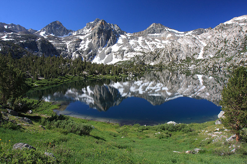 |
| Painted Lady |
 |
| More Snow On Way Up To Glen Pass |
 |
| Looking South From Glen Pass |
 |
| Grand Vistas From Glen Pass |
 |
| Mt. Brewer |
 |
| Beautiful Tarn Below Glen Pass |
 |
| East Vidette & Center Basin |
 |
| Junction Peak As Viewed From Bubbs Creek |
Friday, August 12, 2011
Photo Link & Spot Adventure Link
Spot Adventure Link: http://www.spotadventures.com/trip/view?trip_id=271017
SmugMug Photo Link: http://calicokat.smugmug.com/Hiking/Sierra-Nevada/John-Muir-Trail-July/18498510_CQKWVx
Slideshow Link: http://calicokat.smugmug.com/Slideshows/John-Muir-Trail-2011/18498442_sLZNmf
SmugMug Photo Link: http://calicokat.smugmug.com/Hiking/Sierra-Nevada/John-Muir-Trail-July/18498510_CQKWVx
Slideshow Link: http://calicokat.smugmug.com/Slideshows/John-Muir-Trail-2011/18498442_sLZNmf
A Few Photos.....
Here are some photos, not in any order, just a few to share. Day by Day Trip Report Coming Soon.....
 |
| Starting Off At Happy Isles |
 |
| Just Before The Cables On Half Dome |
 |
| Looking North On Way Up To Glen Pass |
 |
| View North From Glen Pass |
 |
| View North On Way To Forester Pass |
 |
| Frozen Lake North East Of Forester Pass |
 |
| Myself On The Bighorn Plateau |
 |
| View West Above Guitar Lake |
 |
| Relaxing From Camp At Guitar Lake Tarn, Mt. Whitney Behind Me |
 |
| Sunrise Atop Mt. Whintey, Alpine Glow |
 |
| Myself At Sunsise On Whitney |
 |
| Final Stats: 235.0 Miles, +48,400' Of Elevation Gain |
 |
| Alot Of Snow Travel |
 |
| East Of Lake Virginia |
 |
| Just South Of Silver Pass |
 |
| Looking West From Marie Lakes |
 |
| Looking West From Evolution Lake |
 |
| Looking South From Evolution Lake |
 |
| Sunset After Some Thunderstorms |
 |
| Sunset After The Storm |
 |
| Looking South From Sapphire Lake |
 |
| Wanda Lake |
 |
| Looking North On Way Up To Muir Pass |
 |
| Lots Of Beautiful Flowers On The Trail |
 |
| Looking West On Way Up To Palisade Lakes |
 |
| View From Upper Palisade Lake |
 |
| Looking Towards Mather Pass From Upper Palisade Lake |
 |
| Looking West From Mather Pass Ascent |
 |
| Upper Basin |
 |
| Lake Marjorie |
 |
| Looking North On Ascent Of Pinchot Pass |
 |
| Looking North From Pinchot Pass |
Subscribe to:
Posts (Atom)